
Have you ever wondered if Mount Shasta, the picturesque mountain in Northern California, is likely to erupt? With its snow-capped peak and stunning natural beauty, Mount Shasta is not only a beloved tourist attraction but also an active stratovolcano. While the possibility of an eruption may seem concerning, experts have been closely monitoring the mountain's activity to keep us safe. In this article, we will explore the current state of Mount Shasta and shed light on the likelihood of an eruption, providing you with a clearer understanding of this majestic natural wonder.

Geological History of Mount Shasta
Mount Shasta, located in northern California, is a majestic and iconic stratovolcano that has a rich geological history. Its formation can be traced back to millions of years ago, with the first eruptions occurring around 600,000 years ago. The mountain has been shaped by a combination of volcanic activity and glaciation, resulting in its distinctive cone-shaped appearance.
Formation of Mount Shasta
Mount Shasta was formed as a result of the subduction of the oceanic Juan de Fuca plate beneath the North American plate. This subduction zone, known as the Cascadia Subduction Zone, has been responsible for the formation of the entire Cascade Range, which spans from northern California to southern British Columbia.
Over time, magma from the subduction zone rose to the surface, leading to the formation of the volcanic arc that includes Mount Shasta. This process, known as volcanic or magmatic arc, is responsible for the formation of many of the world's most prominent volcanoes.
Mount Shasta's Eruption History
Mount Shasta has a history of both explosive and effusive eruptions. Explosive eruptions are characterized by the ejection of ash, pyroclastic flows, and gas, while effusive eruptions involve the slow extrusion of lava.
The volcano has experienced several major eruptive periods throughout its history, with the most recent significant eruption occurring around 200 years ago. This eruption, known as the Hotlum eruption, resulted in the formation of a new crater and the deposition of ash and pumice in the surrounding areas.
Recent Activity and Dormant Periods
While Mount Shasta has been relatively quiet in recent history, it is important to note that volcanoes can have long dormant periods followed by periods of increased activity. Monitoring efforts have revealed that Mount Shasta has experienced minor eruptions, gas emissions, and earthquakes in the past century.
During dormant periods, the volcano is not considered to be an immediate threat, but the potential for future eruptions cannot be ruled out. It is vital to maintain ongoing monitoring efforts and preparedness measures to ensure the safety of the surrounding communities.
Relationship with the Cascade Volcanic Arc
Mount Shasta is part of the Cascade Volcanic Arc, a chain of volcanoes that stretches from southern British Columbia to northern California. This volcanic arc is the result of ongoing subduction of the Juan de Fuca plate beneath the North American plate.
The Cascade Volcanic Arc is characterized by active volcanism, with notable peaks such as Mount St. Helens and Mount Rainier. Mount Shasta's position within this volcanic arc highlights its geological significance and the dynamic nature of the region.
Understanding Volcanic Eruptions
Volcanic eruptions, while awe-inspiring, can also pose significant risks to human lives and infrastructure. Understanding the processes behind volcanic activity is crucial for predicting and mitigating the hazards associated with eruptions.
Volcanic Activity Explained
Volcanic activity is a result of the movement and interaction of magma, gases, and tectonic plates beneath the Earth's surface. Magma, a molten rock, forms when solid rock beneath the surface melts due to high temperatures and pressure. As magma rises to the surface, it can lead to volcanic eruptions.
Gases, such as water vapor, carbon dioxide, and sulfur dioxide, can become trapped within the magma. The release of these gases during an eruption contributes to the explosive nature of some eruptions.
Mount Shasta's Volcano Type
Mount Shasta is classified as a stratovolcano, also known as a composite volcano. These volcanoes are characterized by their steep slopes and alternating layers of lava, ash, and other volcanic materials. Stratovolcanoes often have explosive eruptions due to the high viscosity of their magma.
The unique geological features of Mount Shasta, including its symmetrical shape and the presence of glaciers, are a direct result of its stratovolcano classification.
Common Triggers for Eruptions
Volcanic eruptions can be triggered by a variety of factors, and predicting them with absolute certainty is challenging. However, certain indicators can be used to assess the likelihood of future eruptions.
One common trigger for volcanic eruptions is the increase in magma supply from the Earth's mantle. This can result in a buildup of pressure within the volcano, eventually leading to an eruption. Additionally, the movement of tectonic plates, such as during subduction or rift zones, can also contribute to volcanic activity.
Signs of an Imminent Eruption
Monitoring techniques play a crucial role in detecting signs of an impending eruption. Scientists closely observe various indicators, including seismic activity, gas emissions, and ground deformation.
Seismic activity involves monitoring the frequency, intensity, and location of earthquakes near the volcano. An increase in seismic activity can indicate movement and pressure within the volcano, potentially signaling an imminent eruption.
Gas emissions, such as the release of sulfur dioxide, can also serve as a precursor to volcanic activity. Monitoring these emissions provides important insights into the volcano's internal processes.
Ground deformation measurements, including the use of GPS and satellite data, can detect any changes in the shape or elevation of the volcano. These measurements help scientists understand the dynamics of magma movement beneath the surface.
Current Geological Conditions
Understanding the current geological conditions of Mount Shasta is essential for assessing the level of volcanic activity and potential hazards. Ongoing monitoring efforts provide valuable data to inform risk assessment and preparedness measures.
Seismic Activity at Mount Shasta
Seismic monitoring stations are strategically placed around Mount Shasta to detect and record vibrations and movements within the volcano. By analyzing the recorded data, scientists can gain insights into the volcano's internal processes and identify any patterns or changes in seismic activity.
The seismic data collected at Mount Shasta helps determine the volcano's overall stability and can provide early indications of possible eruptions.
Gas Emission Studies
Studying the composition and volume of gases emitted by Mount Shasta is another critical aspect of monitoring volcanic activity. Gas emissions, such as sulfur dioxide and carbon dioxide, can provide important clues about the volcano's internal processes.
Gas emission studies involve collecting gas samples near the volcano and analyzing their chemical composition. Continuous monitoring of gas emissions helps scientists detect any unusual changes that may occur in the lead-up to an eruption.
Geothermal Activity: Hot Springs and Fumaroles
Mount Shasta is known for its geothermal activity, which manifests in the form of hot springs and steam vents called fumaroles. These features are a result of the heat generated by the volcanic activity beneath the surface.
Monitoring geothermal activity involves measuring the temperature and chemical composition of the hot springs and fumaroles. Changes in temperature or the presence of new vents can indicate shifts in underground volcanic processes.
Ground Deformation Observations
Ground-based deformation measurements provide valuable insights into any changes in the shape or elevation of Mount Shasta. This information is crucial for understanding the movement of magma beneath the surface and assessing the potential for future eruptions.
Techniques such as GPS measurements and satellite observations are used to monitor ground deformation. By comparing data collected over time, scientists can identify any significant changes that may signal increased volcanic activity.
Monitoring Techniques for Volcanoes
Monitoring volcanic activity is essential for predicting eruptions and ensuring the safety of surrounding communities. Advancements in technology have greatly improved our ability to monitor volcanoes and detect any indicators of future eruptions.
Seismic Monitoring Stations
Seismic monitoring stations are equipped with seismometers, which are sensitive instruments that detect and record vibrations caused by earthquakes. These stations are strategically placed around active volcanoes, including Mount Shasta, to provide comprehensive coverage of seismic activity.
By analyzing seismic data, scientists can monitor volcano-related earthquakes and track any changes in their frequency, intensity, or location. Seismic monitoring is crucial for assessing the stability of the volcano and predicting the likelihood of future eruptions.
Satellite Observations
Satellite observations have revolutionized volcano monitoring by providing a larger-scale perspective. Satellites equipped with specialized sensors can detect volcanic gases and measure changes in ground deformation over large areas.
Satellite imagery allows scientists to track volcanic plumes, monitor changes in the shape of the volcano, and detect any thermal anomalies. The data collected from satellite observations provide valuable insights into volcanic activity, especially in remote or inaccessible locations.
Geochemical Monitoring: Gas and Water
Geochemical monitoring involves studying the composition and behavior of gases and water associated with volcanic activity. This monitoring technique provides crucial information about the volcano's internal processes and can help identify any changes that may precede an eruption.
Collecting and analyzing gas samples from areas surrounding the volcano helps scientists track any variations in gas emissions. Additionally, studying the chemical composition of water sources can reveal any unusual patterns or anomalies that may be linked to volcanic activity.
Ground-Based Deformation Measurements
Ground-based deformation measurements involve monitoring changes in the shape or elevation of a volcano using various techniques. These measurements help scientists understand the movement of magma beneath the surface and assess the potential for future eruptions.
GPS (Global Positioning System) instruments are used to precisely measure ground movement by tracking the positions of multiple monitoring points. By analyzing the data collected from these instruments, scientists can identify any significant changes or trends in ground deformation.

Hazards Associated with Mount Shasta Eruption
Volcanic eruptions pose numerous hazards that can have devastating consequences for both the environment and human populations. Understanding the potential hazards associated with an eruption is crucial for effective disaster preparedness and planning.
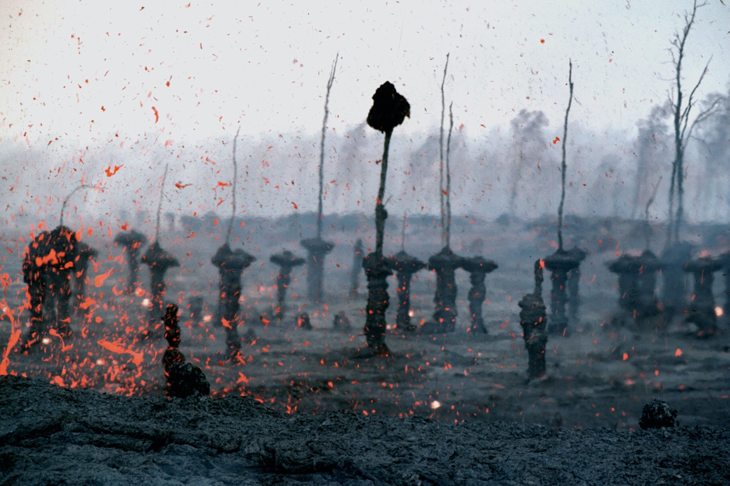
Pyroclastic Flows and Surge
Pyroclastic flows and surges are among the most dangerous volcanic hazards. They involve the rapid movement of hot gas, ash, and volcanic debris down the slopes of the volcano.
Pyroclastic flows are dense, fast-moving currents of hot gas, ash, and rock fragments that can reach speeds of up to 700 km/h. Pyroclastic surges, on the other hand, are more dilute and can travel farther from the volcano.
Lahars and Mudflows
Lahars, or volcanic mudflows, are another significant hazard associated with volcanic eruptions. They occur when volcanic ash, debris, and water combine to form a fast-moving slurry that flows down the slopes of the volcano.
Lahars can be triggered by heavy rainfall, melting snow and ice, or the collapse of volcanic edifices. These flows can be highly destructive, damaging infrastructure and posing a threat to human life.
Ashfall: Living downwind from Shasta
Ashfall is a common hazard during volcanic eruptions, especially for areas downwind from the volcano. Volcanic ash is composed of tiny rock fragments and glass particles that can be carried by wind over long distances.
Ashfall can have detrimental effects on human health, agriculture, infrastructure, and transportation. The abrasive nature of volcanic ash can damage machinery and disrupt power systems, while the inhalation of ash can cause respiratory problems.
Effects on Local Water Supplies and Infrastructure
Volcanic eruptions can have significant impacts on local water supplies and infrastructure. Eruptions can contaminate water sources with volcanic ash, gases, and other pollutants.
Additionally, lahars and mudflows can damage water treatment facilities, pipelines, and reservoirs, leading to disruptions in water supply. Infrastructure such as roads, bridges, and buildings can also be severely affected by volcanic activity, hindering emergency response and recovery efforts.
Community Preparedness and Management
Preparedness and management play a critical role in mitigating the impacts of a volcanic eruption. Communities in the vicinity of Mount Shasta must have robust emergency plans in place to ensure the safety of residents and minimize the loss of life and property.
Volcano Emergency Plans
Developing and implementing volcano emergency plans is essential to effectively respond to an eruption. These plans outline the roles and responsibilities of various agencies, define evacuation procedures, and establish communication protocols.
Volcano emergency plans also provide guidelines for coordinating emergency services, distributing information to the public, and conducting post-eruption assessments. Regular drills and exercises help ensure that emergency response teams are well-prepared for different scenarios.
Community Education Programs
Educating the community about volcanic hazards and proper preparedness measures is a crucial aspect of volcano risk management. Community education programs should focus on raising awareness about volcanic activity, potential hazards, and evacuation procedures.
These programs can include public meetings, workshops, educational materials, and online resources. The goal is to empower individuals with the knowledge and skills necessary to make informed decisions about personal safety during volcanic eruptions.
Evacuation Procedures
Evacuation procedures are an integral part of community preparedness for a volcanic eruption. These procedures should be well-documented, clearly communicated to residents, and regularly practiced through drills and exercises.
Identification of evacuation routes, safe zones, and shelters is essential. Local authorities should establish protocols for issuing evacuation orders, disseminating information, and providing assistance to vulnerable populations, such as the elderly and individuals with disabilities.
Infrastructure and Recovery Plan
Planning for the impact on infrastructure and post-eruption recovery is vital to minimize disruptions and facilitate the restoration of normalcy. Infrastructure and recovery plans should address the restoration of roads, bridges, utilities, and other critical services.
These plans should also consider the potential long-term impacts of a volcanic eruption, including changes to the local landscape, water supply, and environmental conditions. Efforts to assess and mitigate these impacts can aid in the long-term resilience of the affected communities.

Potential Impact on Climate
Volcanic eruptions can have both short-term and long-term effects on climate and weather patterns. Understanding the potential impact of a volcanic eruption on the climate is crucial for assessing the broader implications of volcanic activity.
Volcanic Eruptions and Climate Change
Volcanic eruptions have the potential to influence climate change due to their release of greenhouse gases and aerosols into the atmosphere. Volcanic gases, such as carbon dioxide, can contribute to an increase in global temperatures.
Additionally, volcanic aerosols, consisting of tiny particles and droplets, can reflect sunlight back into space and lead to a cooling effect on the planet. These aerosols can remain in the atmosphere for months or even years, affecting regional and global weather patterns.
Volcanic Gases and the Atmosphere
Volcanic eruptions can release a significant amount of gases into the atmosphere, including water vapor, carbon dioxide, sulfur dioxide, and hydrogen sulfide. These gases can have both direct and indirect effects on the composition and chemistry of the atmosphere.
For example, sulfur dioxide can react with water vapor to form sulfate aerosols, which can scatter sunlight and cause cooling. The release of these gases can also impact air quality, leading to respiratory issues and other health concerns for both humans and wildlife.
Temperature Changes: Short and Long-Term Effects
The injection of volcanic aerosols into the stratosphere can have short-term cooling effects on the Earth's climate. These aerosols reflect sunlight back into space, reducing the amount of solar radiation reaching the surface and leading to a temporary decrease in temperatures.
However, it is important to note that the long-term impact of volcanic eruptions on global temperatures is relatively small compared to the influence of greenhouse gases from human activities. Volcanic aerosols eventually settle out of the atmosphere, resulting in a return to pre-eruption conditions.
Impact on Global Weather Patterns
Volcanic eruptions can also have an impact on global weather patterns. The injection of volcanic aerosols into the stratosphere can disrupt atmospheric circulation, leading to changes in wind patterns and precipitation distribution.
The cooling effect caused by volcanic aerosols can result in shifts in precipitation patterns, with some regions experiencing increased rainfall, while others may experience drought. These changes in weather patterns can have significant implications for agriculture, water resources, and ecosystems.
Probability of Future Eruptions
Predicting volcanic eruptions with certainty is challenging, but ongoing monitoring efforts and data analysis can provide valuable insights into the probability of future eruptions. Scientists use a combination of geological, seismic, and gas monitoring techniques to assess the risk of volcanic activity.
Predicting Volcanic Eruptions
Volcano prediction involves the analysis of various indicators, such as seismic activity, gas emissions, ground deformation, and historical eruption patterns. By analyzing these data sets and looking for patterns or changes, scientists can make informed assessments about the likelihood of future eruptions.
However, it is important to note that predicting the precise timing and magnitude of volcanic eruptions remains a complex and evolving scientific field. Volcanic systems are highly unpredictable, and eruptions can occur without clear warning signs.
Assessing Risk at Mount Shasta
Assessing the risk of future eruptions at Mount Shasta involves evaluating a range of factors, including the volcano's eruption history, current geological conditions, and monitoring data. By understanding the volcano's past behavior and monitoring its current activity, scientists can estimate the probability of future eruptions.
The United States Geological Survey (USGS) and other scientific institutions regularly assess volcanic hazards and provide hazard assessments for Mount Shasta and other volcanoes in the region. These assessments help guide emergency planning and preparedness efforts.
Geological and Seismic Indicators
Geological and seismic indicators are crucial for assessing the probability of future eruptions. Examining the geological history of Mount Shasta, including the frequency and magnitude of past eruptions, provides valuable insights into the volcano's behavior.
Seismic activity is another important indicator. Monitoring earthquake activity near Mount Shasta helps scientists understand the movement of magma and the potential for future eruptions. Changes in seismic activity can provide early warning signs of increased volcanic activity.
Volcanic Hazard Assessment by USGS
The United States Geological Survey (USGS) conducts comprehensive volcanic hazard assessments for active volcanoes in the United States, including Mount Shasta. These assessments consider a range of factors, such as the volcano's eruption history, monitoring data, and potential hazards.
The USGS uses a combination of scientific expertise, monitoring technology, and modeling to assess volcanic hazards. The results of these assessments help inform land-use planning, emergency management, and public safety initiatives.
Impact on Local Flora and Fauna
Volcanic eruptions can have significant impacts on local ecosystems and biodiversity. Mount Shasta, with its unique ecosystem, harbors a diverse range of flora and fauna that could be disrupted by volcanic activity.
Mount Shasta's Unique Ecosystem
Mount Shasta is home to a diverse range of ecosystems, including alpine meadows, coniferous forests, and wetlands. These ecosystems support a variety of plant and animal species, some of which are unique to the region.
The cool, moist climate and volcanic soils in the vicinity of Mount Shasta create a favorable environment for many specialized plants and wildlife. Preserving and protecting these ecosystems is crucial for maintaining biodiversity and supporting resilience in the face of potential volcanic disturbances.
Potential for Species Disruption
Volcanic eruptions can disrupt habitats and threaten the survival of local plant and animal species. The deposition of volcanic ash and the alteration of soil chemistry can negatively impact vegetation, making it difficult for plants to survive and regenerate.
Additionally, changes in water quality, such as acidification or contamination, can have detrimental effects on aquatic ecosystems and the species that rely on them. The disruption of critical habitats can lead to population declines and even extinctions in some cases.
Local Forest and Plant Impact
Forests surrounding Mount Shasta are vulnerable to the impacts of volcanic eruptions. Ashfall can damage leaves and photosynthetic tissues, affect nutrient availability, and block sunlight, impacting the growth and survival of trees and other vegetation.
However, some plant species have adapted to thrive in volcanic environments and can quickly recolonize after eruptions. The timing and severity of eruptions, as well as post-eruption environmental conditions, play a significant role in determining the long-term effects on local forests and plants.
Effects on Fish and Wildlife
Volcanic eruptions can have both direct and indirect effects on fish and wildlife populations. The deposition of volcanic ash into rivers and lakes can smother fish eggs, larvae, and bottom-dwelling organisms.
Changes in water chemistry and temperature resulting from volcanic activity can also impact aquatic ecosystems and the species that inhabit them. Additionally, disruptions in food availability and habitat quality can have cascading effects on wildlife populations, affecting their abundance and distribution.
Reflections and Conclusions
Studying the geological history and current conditions of Mount Shasta provides valuable insights into the nature of volcanic activity and its potential impact on the surrounding area. Balancing the technological tools at our disposal with the inherent unpredictability of nature is essential for effective preparedness and management.
Balancing Technological Predictions and Unpredictability of Nature
While advancements in monitoring technology have greatly improved our ability to predict volcanic eruptions, the inherent unpredictability of nature makes it impossible to forecast eruptions with complete certainty. Volcanoes are complex systems, and eruptions can occur without clear warning signs.
It is important to balance the insights gained from monitoring techniques with an understanding of the inherent uncertainties of volcanic activity. Continual improvement in monitoring technology and data analysis can enhance our ability to predict eruptions, but the need for ongoing vigilance and preparedness remains paramount.
Ongoing Monitoring and Community Preparedness
Ongoing monitoring efforts and community preparedness are essential for minimizing the impact of volcanic eruptions. Regular monitoring of Mount Shasta's seismic activity, gas emissions, and ground deformation provides crucial data for hazard assessments.
Community preparedness programs, including education, emergency planning, and infrastructure management, ensure that residents are well-informed and ready to respond in the event of an eruption. By working together, scientists, government agencies, and local communities can enhance the overall safety and resilience of the region.
Considerations for the Future
As our understanding of volcanic activity continues to evolve, it is important to consider the potential impacts of future eruptions on Mount Shasta and its surrounding areas. Long-term planning efforts should include robust hazard assessments, land-use planning, and infrastructure resilience strategies.
Continued research on volcanic activity, advances in monitoring technology, and collaboration among scientists, government agencies, and communities will contribute to our ability to anticipate and respond to volcanic hazards.
Maintaining Respect for the Power of Volcanoes
Lastly, it is essential to maintain a deep respect for the power and unpredictability of volcanoes. While scientific advancements and preparedness measures can mitigate the risks associated with volcanic eruptions, they cannot eliminate them entirely.
Understanding and appreciating the natural forces at play in volcanic regions, such as Mount Shasta, remind us of the awe-inspiring and sometimes humbling nature of our planet. As we navigate the complexities of living in volcanic landscapes, it is crucial to approach these environments with respect and a commitment to safety.